
November 24, 2020
Rules for Preparing a Cadastral file for Real Estate
1. Paperwork of a Cadastral file
2. The components of a cadastral file
2.1. Cover of a cadastral file
2.2. Documents confirming state registration of rights to real estate
2.3. Cadastral data of a land plot
2.4. Cadastral data of buildings and structures
2.5. Cadastral data of perennial plantings
3. Making changes to a cadastral file
Legislation related to and used in this Article
1. Decree of the President of the Republic of Uzbekistan dated 27.07.18 No. UP-5490 “On Measures to Further Improve the System of Protection of the Rights and Legitimate Interests of Business Entities”;
2. Decree of the President of the Republic of Uzbekistan dated 07.09.2020 No. UP-6061 “On Measures to Radically Improve the System of Land Registration and State Cadastres”;
3. Appendix to the Resolution of Goskomzemgeodezkadastr dated 22.10.2015 No. 33, registered by the Ministry of justice dated 03.11.2015 No. 2725 “Rules of Preparation of Cadastral file For Real Estate Objects”;
4. Appendix No. 1 to the Resolution of the CM of the Republic of Uzbekistan dated 29.12.18 No. 1060 “Regulations on the Procedure for State Registration of Rights to Real Estate Objects”.
Cadastral file – a collection of documents that individualize the object of real estate. Namely, it is prepared for the purpose of determining the type, characteristics, volume, value and other indicators of real estate (paragraph 2 of the Rules for preparing the cadastral file for real estate objects registered under the Ministry of justice dated 03.11.15 No. 2725). As it is known, all real estate transactions require individualization of real estate, which indicates on the great importance of a properly compiled cadastral file. This article is devoted to a detailed overview of what a cadastral file is, what documents it consists of, what objects its paperwork is mandatory and the procedure for changing and paperwork of a cadastral file.
1. Paperwork of a Cadastral file
A cadastral file is compiled by summarizing materials and information about the location, legal status, size, quality characteristics and value of real estate. In addition, a cadastral file includes information about current changes in the state of real estate, as well as in documents confirming rights to real estate, which are also an integral part of a cadastral file (paragraph 3 of the Rules for preparing a cadastral file for real estate objects registered under the Ministry of justice dated 03.11.15 No. 2725).
To prepare a cadastral file, you should contact the branch of the state enterprise of land management and real estate cadastre at the location of the real estate (hereinafter – ” Branch of the cadastre»)[1]. An individual or legal entity shall submit an application for paperwork of a cadastral file, which is accompanied by the following documents:
- Documents confirming the rights to land plots, buildings, structures and perennial plantings;
At the moment, the documents confirming the rights to real estate are a) an extract from the state register of rights to real estate (Appendix No. 1 to the RCM of the Republic of Uzbekistan dated 29.12.18 No. 1060); b) a certificate of registration of rights to real estate, but only issued before October 1, 2018. By Presidential decree No. UP-5490 dated 27.07.18, registration of certificates of registration of rights to real estate was canceled from October 1, 2018. At the same time, the procedure for issuing extracts from the state register of rights to real estate, which are documents confirming the rights to real estate, was introduced. However, all certificates issued before this change are also valid.
- Court’s decision – when the transfer of rights to buildings, constructions and perennial plantings made by court decision;
- Other documents at the disposal of legal entities and individuals confirming the rights to real estate.
The application can be submitted either in person or via telecommunications channels.
On the day of receipt of the application to the Branch of the cadastre, a contract for the preparation of the cadastral file is concluded between the Branch of the cadastre and the individual or legal entity that submitted the application.
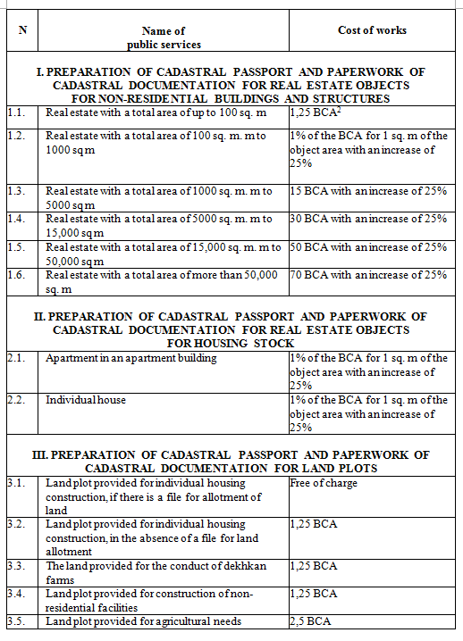
The cost of state services for paperwork of a cadastral file is provided in the following table (according to the Appendix to the RCM of the Republic of Uzbekistan dated 10.07.14 No. 186).
Depending on the complexity of the cadastral object, the preparation of a cadastral file is carried out in the following terms:
- for the residential part of real estate objects:
- apartment in an apartment building-up to 7 days;
- individual housing-up to 10 days;
- for the non-residential part of real estate objects:
- real estate with a total area of up to 100 square meters. m-up to 10 days;
- real estate with a total area of 100 to 1000 square meters. m-up to 15 days;
- real estate with a total area of 1000 to 5000 sq. m. m-up to 20 days;
- real estate with a total area of 5,000 to 15,000 square meters. m-up to 25 days;
- real estate with a total area of 15,000 to 50,000 square meters. m-up to 30 days;
- real estate with a total area of more than 50,000 square meters. m – up to 45 days.
In General, the cadastral case consists of such parts as a) cadastral data of land plot; b) cadastral data of buildings and structures; C) cadastral data of perennial plantings. However, at the request of individuals, it can be prepared separately, if real estate objects and rights to them arose at different times.
It is prepared in two copies, one copy for holder, and the second is stored in the archives of the Branch of the cadastre. The prepared cadastral file is checked by the chief engineer of the Branch of the cadastre and a specialist in state registration of rights to real estate within one day.
2. The Components of a Cadastral file
2.1. Cover of a Cadastral file
It is prepared according to the standard form according to Annex 9 to the Rules of 03.11.15 No. 725. The cover indicates the name of the owner of the right to the property and its functional use. The title page and contents of the cadastral file are also being prepared. The title page is signed by the head, chief engineer and executor of the cadastre Branch. This is followed by an explanatory note prepared by the contractor, which reflects the documents confirming the rights to real estate (an extract or certificate from the state register of rights to real estate).
2.2. Documents Confirming State Registration of Rights to Real Estate
After the state registration of real estate rights, information about the state registration of real estate rights is entered in a cadastral file in accordance with the standard form given in Annex 11 to the Rules of 03.11.15 No. 725.
Rights to real estate objects, the emergence, transfer, restriction and termination of these rights are subject to state registration, the rights come into force after state registration. A description of the procedure for state registration of rights to real estate is available here.
2.3. Cadastral Data of a Land Plot
When preparing cadastral data of a land plot, work is performed to study the topographic data of the land plot, documents that restrict the rights to them and the availability of easements. An inventory of the land plot is carried out, as well as data on the boundaries and area of the land plot are verified. The following documents are prepared:
- the Act of defining and approving the boundaries of the land plot (hereinafter – the “Act“)
Must be drawn up in accordance with the standard form given in Annex 1 to the Rules of 03.11.15 No. 725. It must contain the following data:
- name, date and number of the document confirming the right to the land plot;
- address of the land plot location;
- description of the land plot boundaries;
- total area of land plot according to the documents and the actual;
- functional use of the land plot specified in the documents on granting the land plot, and the actual type of use;
- bonus points and standard value of land used in agriculture;
- other necessary information about the land plot.
The act is signed by the originator and the director or authorized representative (in the case of a legal entity); by an individual or its representative (in the case of an individual). The Act is also approved by the owners of the right to adjacent land plots.
- Cadastral plan of the land plot
An electronic-digital cadastral plan of the land plot is drawn up. It must contain the following information:
- buildings and structures, as well as other geographical features;
- protected areas of the land plot established by state authorities and borders of illegally occupied land (if any);
- adjacent land plots and names of the owners of the right to them.
Cadastral plan is printed and signed by the contractor who drafted the plan, the owner of the rights to the land and agreed with the owners of rights in adjacent land, and attached to the Act as an integral part.
- Cadastral passport of the land plot
It is prepared according to the standard form given in Annex 2 to the Rules of 03.11.15 No. 725. It contains the following information:
- owner of the right to land: full corporate name of the legal entity or surname, first name, patronymic of the individual;
- functional use of the land plot according to the document and actual use;
- address of the land plot location;
- cadastral number of the land plot;
- type of land title;
- term of use of the land plot;
- the total area of the land plot-according to the document on granting the land plot and actually used;
- name, date and number of the document confirming the right to the land plot;
- information about restrictions on the right to land, easements, and other conditions – types, content, grounds, and term of validity;
- information about protected areas – the type of object with the established protected area and the area of the protected area;
- information about perennial plantings on the land plot: types and quantity;
- information about the state registration of rights to land – the registration number and date of entry in the State register of rights to real estate and transactions with them, the number and date of issue of the certificate of state registration (if any);
- information about land plot assessment – standard value of agricultural land, year of assessment;
- other information related to special structures.
2.4. Cadastral Data of Buildings and Structures
The following documents are prepared:
- Cadastral passport of buildings and structures
It is prepared according to the standard form given in Annex No. 8 to the Rules of 03.11.15 No. 725. It must contain the following information:
- full corporate name of the legal entity or surname, first name, patronymic of the individual;
- types of buildings and structures;
- name, date and number of the document confirming the right to buildings and structures;
- name, date and number of the document restricting or revoking rights to buildings and structures, term of restriction;
- if there is a special procedure for using buildings and structures – the name, date and number of the document that is the basis for its establishment, a brief description of the special procedure and the validity period;
- information about the cost of buildings and structures;
- construction information;
- information about the area and volume of buildings and structures;
- information about providing engineering telecommunications;
- information about using;
- information about special structures.
In addition, the inventory value of buildings and structures is determined, architectural and construction drawings and descriptions of underground structures are compiled.
When alienating buildings and structures whose construction is not completed, the following data is entered in the cadastral file:
- name of the holder;
- availability of documents on granting a land plot, information on state registration of the right to a land plot;
- land plot plan with buildings and structures marked;
- name of the object and year of its construction start;
- availability of design and estimate documentation and permission from the architecture and construction authorities to perform construction and installation works;
- list of objects completed by construction, but not commissioned by the state Commission;
- condition of unfinished buildings and structures;
- the cost of unfinished construction of the object, if necessary, estimated by appraisal organizations.
2.5. Cadastral Data of Perennial Plantings
Under perennial plantings is necessary to understand the gardens, vineyards, mulberry trees and other forest plants. Cadastral data of perennial plantings are indicated together with cadastral data of the land plot. If necessary, a plan of land on which there are long-term plantings is drawn up (Rules for preparing a cadastral file for real estate objects registered by the Ministry of justice dated 03.11.15 No. 2725).
3. Making Changes to a Cadastral file
Changes to a cadastral file are made at the request of the owners of the right or their representatives. Also, such an application is accompanied by documents on the basis of which changes are made (paragraph 43 of the Rules for preparing a cadastral case for real estate objects registered by the Ministry of justice dated 03.11.15 No. 2725). Changes to a cadastral file are made in the following cases:
- During reconstruction with changes in structural elements, the number of premises of buildings and structures;
- When a part of a land plot is alienated (a new Act and land plot plan with the designated alienated plot are prepared).
If the type of right or the owner of the right changes, a cadastral file is reissued accordingly. It should be noted that without changing the structural elements, the number of premises of buildings and structures, repeated technical inventory of the real estate object is prohibited in the event of a change in the right and / or the owner of the right. Changes are made to 2 copies of a cadastral file. If a cadastral file is lost or damaged, a copy of the cadastral file is prepared from the second copy stored in the Branch of the cadastre. At the same time, the head of the Branch of the cadastre makes an entry “the copy is correct” on each sheet of the copy and signs it. A copy of a cadastral file is prepared within 2 (two) business days from the date of receipt of the application.
Cadastral records of land plots that are in reserve, as well as land plots allocated on agricultural land, are prepared on the basis of requests from district departments of agriculture. And for land plots allocated on non-agricultural land, they are prepared on the basis of requests from district construction departments based on orders from district (city) khokimiyats. The cost of preparing cadastral files covered by the owners of the land in state registration of rights to land (paragraph 1 of item 5 of the Presidential Decree of the Republic of Uzbekistan dated 07.09.2020 No. 6061).
[1] By Presidential Decree dated 07.09.2020 № UP-6061 State Committee of Uzbekistan on land resources, geodesy, cartography and state cadastre was reorganized into the Agency for cadastre upon the State tax Committee of Uzbekistan.
[2] Basic Calculated Amount which is 223,000 Soums (approximately $21) on the date of the publication of the Article.